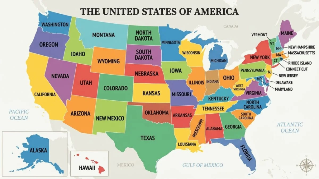

A US map with state names is one of the most useful study and reference tools you can keep nearby. Students use it to learn geography, travelers use it to plan routes, and teachers print it for classroom walls. This guide explains how to read a US map with state names, where each of the 50 states sits and how to memorize them.
A US map with state names shows all 50 states, each labeled so you can see its location and neighbors. The 48 contiguous states form the main shape, while Alaska and Hawaii usually appear as small insets. Many versions also add capitals and two-letter abbreviations.
Below you will find a full table of states, abbreviations and capitals, a region-by-region breakdown, facts about the biggest and smallest states, and practical tips for printing a map that stays easy to read
What a US Map with State Names Shows
At its simplest, a US map with state names draws the outline of every state and writes its full name inside or beside it. Small states, especially in the Northeast, often get a label with a thin line pointing to them because the name will not fit inside the border.
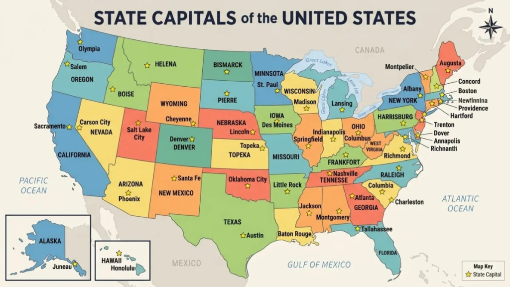
Most versions add a few extras on top of the names:
- Capitals: usually marked with a star or a dot.
- Abbreviations: the two-letter postal codes, such as TX for Texas.
- Major cities and rivers: useful for travel and general reference.
- Color coding: often used to separate regions or to stop neighboring states from blending together.
The best choice depends on the job. A student needs clear labels and plenty of white space, while a traveler may prefer a map that also shows highways and big cities.
Quick Facts About the US States
These basic facts make any US map with state names easier to understand:
- The United States has 50 states, plus the federal district of Washington, DC.
- Forty-eight states are contiguous, which means they share borders and sit together on the North American mainland.
- Alaska lies in the far northwest of North America, and Hawaii is an island chain in the Pacific Ocean.
- Delaware was the first state to ratify the Constitution, on December 7, 1787.
- Alaska became the 49th state on January 3, 1959, and Hawaii became the 50th on August 21, 1959.
US Map with State Names by Region
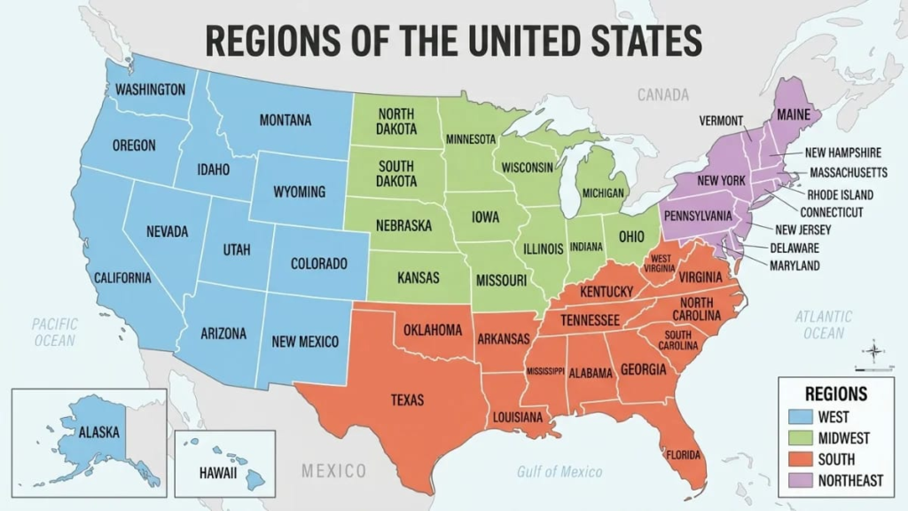
The US Census Bureau groups the states into four regions: Northeast, Midwest, South and West. Learning the map one region at a time is far easier than facing all 50 states at once.
| Region | States | Number |
| Northeast | Connecticut, Maine, Massachusetts, New Hampshire, Rhode Island, Vermont, New Jersey, New York, Pennsylvania | 9 |
| Midwest | Illinois, Indiana, Michigan, Ohio, Wisconsin, Iowa, Kansas, Minnesota, Missouri, Nebraska, North Dakota, South Dakota | 12 |
| South | Delaware, Florida, Georgia, Maryland, North Carolina, South Carolina, Virginia, West Virginia, Alabama, Kentucky, Mississippi, Tennessee, Arkansas, Louisiana, Oklahoma, Texas | 16 |
| West | Arizona, Colorado, Idaho, Montana, Nevada, New Mexico, Utah, Wyoming, Alaska, California, Hawaii, Oregon, Washington | 13 |
The South has the most states, and the Northeast has the fewest. Other sources draw regional lines differently, so a textbook map may not match this one exactly.
All 50 States with Abbreviations and Capitals
This table works as a text version of a US map with state names. Place it beside a blank map and check your answers as you go.
| State | Abbreviation | Capital | Region |
| Alabama | AL | Montgomery | South |
| Alaska | AK | Juneau | West |
| Arizona | AZ | Phoenix | West |
| Arkansas | AR | Little Rock | South |
| California | CA | Sacramento | West |
| Colorado | CO | Denver | West |
| Connecticut | CT | Hartford | Northeast |
| Delaware | DE | Dover | South |
| Florida | FL | Tallahassee | South |
| Georgia | GA | Atlanta | South |
| Hawaii | HI | Honolulu | West |
| Idaho | ID | Boise | West |
| Illinois | IL | Springfield | Midwest |
| Indiana | IN | Indianapolis | Midwest |
| Iowa | IA | Des Moines | Midwest |
| Kansas | KS | Topeka | Midwest |
| Kentucky | KY | Frankfort | South |
| Louisiana | LA | Baton Rouge | South |
| Maine | ME | Augusta | Northeast |
| Maryland | MD | Annapolis | South |
| Massachusetts | MA | Boston | Northeast |
| Michigan | MI | Lansing | Midwest |
| Minnesota | MN | Saint Paul | Midwest |
| Mississippi | MS | Jackson | South |
| Missouri | MO | Jefferson City | Midwest |
| Montana | MT | Helena | West |
| Nebraska | NE | Lincoln | Midwest |
| Nevada | NV | Carson City | West |
| New Hampshire | NH | Concord | Northeast |
| New Jersey | NJ | Trenton | Northeast |
| New Mexico | NM | Santa Fe | West |
| New York | NY | Albany | Northeast |
| North Carolina | NC | Raleigh | South |
| North Dakota | ND | Bismarck | Midwest |
| Ohio | OH | Columbus | Midwest |
| Oklahoma | OK | Oklahoma City | South |
| Oregon | OR | Salem | West |
| Pennsylvania | PA | Harrisburg | Northeast |
| Rhode Island | RI | Providence | Northeast |
| South Carolina | SC | Columbia | South |
| South Dakota | SD | Pierre | Midwest |
| Tennessee | TN | Nashville | South |
| Texas | TX | Austin | South |
| Utah | UT | Salt Lake City | West |
| Vermont | VT | Montpelier | Northeast |
| Virginia | VA | Richmond | South |
| Washington | WA | Olympia | West |
| West Virginia | WV | Charleston | South |
| Wisconsin | WI | Madison | Midwest |
| Wyoming | WY | Cheyenne | West |
Eight states begin with the letter M, and each has a different two-letter code. That makes them a common source of mistakes on quizzes.
How the 48 Contiguous States Sit on the Map
When you look at a US map with state names, it helps to read it in bands rather than state by state. Here is a simple way to scan the mainland from west to east:
- Pacific coast: Washington, Oregon and California run along the western edge.
- Rocky Mountain and desert states: Idaho, Montana, Wyoming, Nevada, Utah, Colorado, Arizona and New Mexico fill the interior west.
- Great Plains: North Dakota, South Dakota, Nebraska, Kansas and Oklahoma form a block through the middle, with Texas to the south.
- Great Lakes and Upper Midwest: Minnesota, Wisconsin, Michigan, Illinois, Indiana and Ohio surround the lakes.
- Deep South and Gulf Coast: Louisiana, Mississippi, Alabama, Georgia and Florida stretch along the Gulf and the Atlantic.
- Atlantic coast and New England: the smaller states from Maryland up to Maine sit close together in the northeast.
Reading in bands also shows you why the eastern states look crowded. They are smaller and were settled earlier, so their borders were drawn around rivers, coastlines and colonial boundaries.
Alaska, Hawaii and Washington, DC on the Map
Most maps place Alaska and Hawaii in boxes near the bottom left, so the page stays compact. This is a layout choice, and the insets are often not drawn to the same scale as the mainland. Alaska is far larger than it looks in the corner.
Washington, DC sits between Maryland and Virginia and is marked with a small dot because it is so small. It is a federal district and not part of any state, which is why a US map with state names still shows 50 states, not 51.
US Territories Not Always Shown
The United States also has inhabited territories: Puerto Rico, Guam, the US Virgin Islands, American Samoa and the Northern Mariana Islands. They are not states, and most maps leave them off.
If you need them, look for a map titled as a United States and territories map. A standard US map with state names is designed to show the 50 states only.
Largest and Smallest States
Size is one of the first things people check on a US map with state names. The table below lists the extremes, with approximate figures.
| Category | State | Detail |
| Largest by area | Alaska | More than 660,000 square miles in total area |
| Second largest by area | Texas | The largest of the 48 contiguous states |
| Smallest by area | Rhode Island | Roughly 1,500 square miles in total area |
| Most populous | California | Approx. 39 million people (2020 census) |
| Least populous | Wyoming | Approx. 577,000 people (2020 census) |
Alaska is more than 400 times larger than Rhode Island by total area (approx.). Yet on a classroom wall map, the two can look surprisingly close in size because of the inset.
Borders, Coasts and the Four Corners
A good US map with state names also makes borders easy to follow. A few useful patterns:
- Mexico border: California, Arizona, New Mexico and Texas.
- Canada border: 13 states, from Alaska and Washington in the west to Maine in the east, counting water boundaries.
- Great Lakes: eight states touch the lakes: Minnesota, Wisconsin, Illinois, Indiana, Michigan, Ohio, Pennsylvania and New York.
- Four Corners: Arizona, Colorado, New Mexico and Utah meet at a single point.
Types of US Maps You Can Choose From
Not every US map with state names serves the same purpose. These are the main types:
- Political map: shows state borders and names, and is the standard choice.
- Blank outline map: shows borders only, so you can test yourself.
- Abbreviation map: uses two-letter codes, which is handy for small states.
- Capitals map: adds stars or dots for capital cities.
- Physical map: shows mountains, rivers and terrain.
- Road map: adds highways and major cities for travel.
Many learners use two versions together: a labeled map to study and a blank one to quiz themselves.
How to Choose and Print a US Map with State Names
A printable US map with state names is only useful when you can read it. A few checks before you hit print can save a lot of frustration.
- File type: PDF is easiest for printing, while SVG stays sharp when you zoom in or enlarge it.
- Resolution: around 300 dpi is a common standard for a clean print.
- Orientation: landscape fits the shape of the country best.
- Paper size: pick Letter or A4 to match your printer.
- Small states: zoom in on the Northeast to confirm labels are readable.
- Color or black and white: color helps with regions, while black and white saves ink for worksheets.
If a map looks blurry on screen, it will look worse on paper. Choose the highest quality version you can find and avoid screenshots.
Easy Ways to Memorize the 50 States
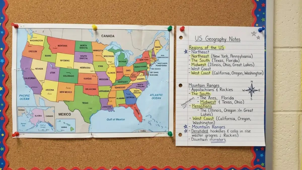
Memorizing 50 names feels big, but a clear method makes it manageable. Here is a plan that many learners find realistic:
- Learn by region: spend a day or two on each of the four regions rather than all 50 at once.
- Study with a labeled map first: read the names aloud as you point to each state.
- Switch to a blank map: write the names yourself and check the answers.
- Use neighbors as clues: if you know Oregon, you can find Washington, Idaho, Nevada and California.
- Quiz yourself often: short daily sessions work better than one long one.
Within a week of steady practice, most people can label the mainland states with only a few mistakes. The capitals take longer, so treat them as a second stage.
States People Often Confuse
Some states look or sound alike, and a US map with state names helps you separate them. Watch for these pairs and groups:
- Iowa, Idaho and Ohio: similar spellings in different parts of the country.
- Virginia and West Virginia: neighbors with different capitals and regions on the Census list.
- The Dakotas and the Carolinas: pairs that share a name but are separate states.
- Kansas and Arkansas: often confused in speech because of the ending sound.
- Michigan, Minnesota, Mississippi and Missouri: four M states in different regions.
- Washington state and Washington, DC: one is in the Pacific Northwest, and the other is on the East Coast.
State Capitals That Surprise People
Many capitals are not the largest city in the state. This is a common trap, so a labeled capitals map is a good companion to a US map with state names.
- California: Sacramento, not Los Angeles.
- New York: Albany, not New York City.
- Texas: Austin, not Houston or Dallas.
- Florida: Tallahassee, not Miami.
- Illinois: Springfield, not Chicago.
- Washington: Olympia, not Seattle.
- Pennsylvania: Harrisburg, not Philadelphia.
Alaska has a special case too. Juneau is reachable only by air or sea, since no road links it to the rest of the state.
Who Uses a US Map with State Names?
The audience is wider than most people expect. Teachers print maps for lessons, and students use them for tests and homework. Travelers use them to see how far one state is from another.
Businesses use a US map with state names to plan shipping zones and sales territories. Trivia fans and game players use it for quizzes and puzzles.
Using a US Map with State Names for Road Trips
A US map with state names is also a quick planning tool for travel. You can count how many state lines a route crosses, spot the states you would pass through and see which neighbors are close enough for a side trip.
One detail catches many travelers out: time zones. The mainland has four zones, Eastern, Central, Mountain and Pacific, and the dividing lines do not always follow state borders. Several states, including Texas, Florida and Tennessee, are split between two zones, so check the local time before you book a tight connection.
Remember too that a map shows straight lines and borders, not driving time. A short gap between two states on paper can still mean a long drive through mountains or desert.
Mistakes to Avoid When Reading a Map
Even a clear US map with state names can mislead you if you read it carelessly. These are the most common slips:
- Judging size by the inset: Alaska and Hawaii are usually shrunk or moved, so their real size and position are different.
- Trusting small labels: crowded areas like New England can hide names, so double-check with a table.
- Mixing up abbreviations: codes such as MI, MN, MS and MO look alike at a glance.
- Using a low-quality image: blurry text makes it easy to misread a name.
- Assuming the capital is the biggest city: as shown above, this is often wrong.
Final Thoughts
A US map with state names is simple, but it does a lot of work. It shows you where each of the 50 states sits, how they group into regions and how they connect through shared borders.
Start with a labeled map, move to a blank one and use the tables in this guide to check your work. With a little regular practice, the whole country becomes easy to picture.
FAQs
How many states are on a US map with state names?
A standard US map with state names shows 50 states. Some versions also mark Washington, DC.
What are the four regions of the United States?
The Census Bureau lists the Northeast, Midwest, South and West.
Which is the largest state on the map?
Alaska is the largest state by area, and Texas is the largest of the 48 contiguous states.
Which is the smallest state?
Rhode Island is the smallest state by area.
Is Washington, DC a state?
No. It is a federal district and is not part of any state.
Can I print a US map with state names for free?
Many websites offer free printable versions, but check the usage terms before sharing or selling a map.
What is the best way to learn the states?
Study one region at a time, then use a blank map to quiz yourself.
Why do Alaska and Hawaii appear in boxes?
They are placed in insets to keep the map compact, and they are often not drawn to the same scale.